Ltd.
We have received copies of some of the responses to the draft JCS - please see below
JCS Consultation, Pre-Submission Responses
-
‣Cllr Ian Bickerton JCS Pre-Submission Response Aug 2014.pdf
-
‣Martin Horwood MP - JCS pre-submission objections August 2014 v2.pdf
Cheltenham Borough Councillor Responses:
‣Cllr S Jordan.pdf - Leader of the Council
‣Cllr Roger Whyborn.pdf - Cabinet, Sustainability
‣Cllr A McKinley.pdf - Cabinet, Built Env.
-
‣LIB DEM JCS Response Consultation input - Controlling Party
Parish Councils, CPRE, STC
THE BACKGROUND
When the present coalition government came to power in 2010 they scrapped the previous government’s ill-conceived housing policy, saying the views and needs of local communities would now be of paramount importance. This sounded encouraging, but sadly it is NOT happening. In the panic to try and kick-start economic recovery they have looked to house building, and in March 2012 set up the National Planning Policy Framework, (NPPF) a short document (only 50 pages) of ‘broad brush’ policies, generally pro-development, that is sustainable development but also contains strong protection for the greenbelt and open countryside. This has put pressure on local authorities to bring strategic and local plans up-to-date and be compliant with the new national framework.
However, even before the NPPF came in, Cheltenham, Gloucester and Tewkesbury had come together to devise a combined plan, called the Joint Core Strategy (JCS), a first draft was put out for public consultation in December 2011. Overwhelmingly the Public, Parish Councils and other Stakeholders wanted a cautious approach, presenting evidence for scenario A, 16,200 additional houses across the three districts, and stressing the importance of a brownfield first policy; this was rejected with brief commentary in an appendix to an external consultant report.
WHERE WE ARE NOW
Since that initial public consultation the three councils have been working to advance the JCS. Under the terms of the NPPF, they need to demonstrate a five year housing land supply plan, failing this causes some difficultly with the Planning Inspectorate who have the power to overrule planning committees and allow development. However, development needs to be sustainable and by the definition of the NPPF it has to be ‘to the benefit of future generations’.
The planning officers have now produced a second draft JCS, this first went to Tewkesbury Borough Council on the 3rd Sept., full debate was not allowed, some councillors were denied the chance to speak and public questions were not permitted which is astonishing given the importance of the JCS; the conservative councillor Adam Tugwell has subsequently resigned from the party over the JCS. At Cheltenham Borough Council on the 5th Sept. there was a cabinet whip in place by the Lib Dems at the, our Ian tried to get some important amendments to JCS Council Resolution in order to protect the Greenbelt and open countryside at Leckhampton. In debate, many councillors were expressing concern on missing evidence documents, traffic analysis and calling for verification of the population projections by the Office of National Statistics. Cllr Duncan Smith and seconded by Andrew Chard made a valiant effort to protect Leckhampton & Up Hatherley, putting forward a resolution to remove these sites from the JCS strategic sites, Ian and Cllr Les Godwin spoke in support but all evidence fell on deaf ears with the lib dem majority.
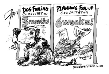
Gloucester City Council gave the nod on the JCS without serious debate and so we ended up with a flawed plan with much of the vital evidence not in place, a plan now being pushed through to a rushed public consultation.
A second draft JCS housing target of 33,500 houses has been set, but by no means unanimously. Many councillors had serious reservations and the thinking was no plan made us vulnerable to opportunistic developers banking on appeals. However, in our view and the majority of Parish Councils is that delaying a month to get the plan right would not have been a problem, given that the JCS is three or more years down the track and many important evidence documents will become available very soon.
This second draft JCS will go out for public consultation, from 15th October - 25th November 2013.
THE JCS HOUSING TARGET ISSUES
The Department of Communities & Local Government (DCLG) April 2013 report on household formation across England validated the views of hundreds of Cheltenham residents, many Parish Councils and organisations who got involved in the previous JCS Public Consultation. Average household sizes or the average number of people who live in a household has stabilised over the last twenty years. The chart below shows ONS census data, verified and referenced, the three districts of Gloucester, Cheltenham and Tewkesbury are showing broadly flat trends and not affected by short term fluctuations in the economy.
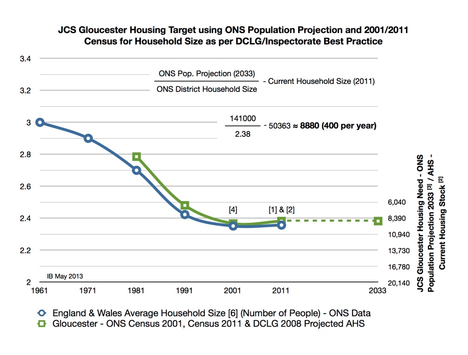
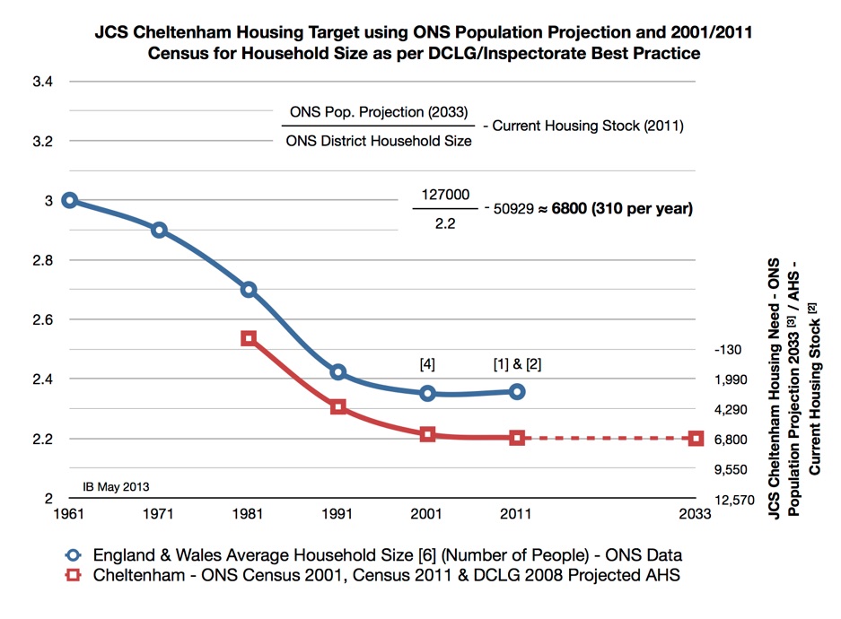
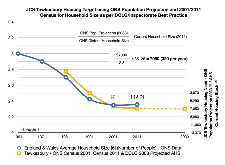
However, the JCS officers switched to an alternate population projection, moving away from the verified long term projection to 2035 published in March 2012 to an interim short term projection. The interim estimate pulled in some of the 2011 census data, which is more UK generic and is not complete hence the shorter term and the warnings published with the table.
The recent Echo article, 10th Oct. 2013, 'No Baby Boom in county as New-Borns total falls', reported on the falling number of babies and population was very timely with important decisions on the Joint Core Strategy (JCS) being made on housing numbers. The article led us to look at the detail of how the county population was changing and the Office of National Statistics (ONS) and the Department of Communities and Local Government (DCLG) confirm the findings. Some recent county work has shown that the natural change, births minus deaths over the period 2001 to 2011 is just 511 per year. This work, the Strategic Housing Market Assessment, 9th May 2013 - by HDS Planning, looked at the detail of the county demographics, exactly where the population increase was coming from and the numbers and threw up some surprises. As stated the natural population in the county, as measured by census, was 511 per year, net internal migration was 2,122 and net international migration 492.
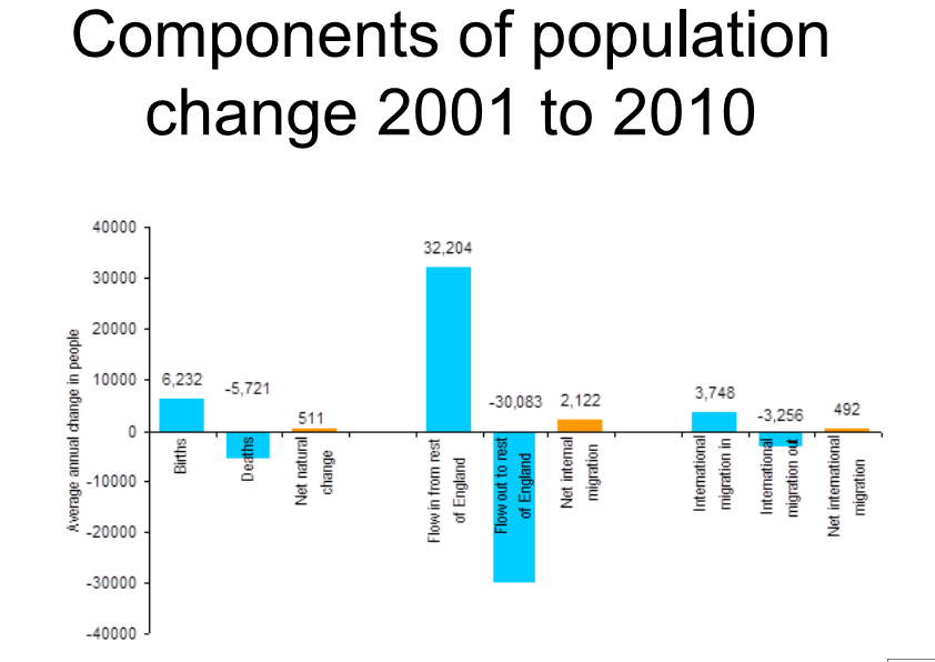
The fact that the natural increase in population had slowed was not expected in the population projections being used in the JCS and indeed in the new Housing Targets, in fact the ONS Interim population projection still has natural increases of population for Gloucester, Tewkesbury & Cheltenham (JSC area) estimated at 960/yr, 160yr and 610/yr respectively, total of 1730/yr which is three times the actual annual county increase seen in the 2011 census.
Talking to the ONS, Suzanne Dunsmith (Head of Population Projections and author), she explained the problem with this work and warned of the likely over estimate on birth rates on the interim projections and told us other validated projections are available published in 2012 and advised us to use them. We hope the JCS officers will be looking at the numbers again and the population questions being raised, of course, this makes a huge difference in the housing targets, some 24,000 people or 10,000 houses. Currently, the longer term and validated ONS population projections fit the county profile and the use of these figures should go some way into protecting the JCS greenbelt and open countryside.
Right now the following sites are under consideration for housing along the A46: 1075 houses at Leckhampton/Shurdington, 795 at Chargrove Lane, 175 at Brizen Farm (with a further 2 possible phases) and 1548 at Brockworth, all unnecessary sites and only in the plan due to errors in the population projections.
Let's look at another objective source of data, the South West Observatory:
http://www.swo.org.uk/census-2011/local-authorities/#.UfJwt6wreSo
POPULATION INCREASE 2001 to 2011,MEASURED BY CENSUS
Area Population 2011 Census % change from 2001 Census
Gloucestershire 597,000 +5.7%
Population increase over the 10 years from 2001 to 2011, measured by census is 5.7%, not really too different from the England & Wales figure of 7.1%.
Next take the current housing stock across the JCS area, measured by census at 2011, Gloucester (50363), Tewkesbury (35,126) & Cheltenham (50,929), TOTAL 136,418
If you were to grow the housing stock at the same rate as population increase in the previous 10 year period, this assumes economic growth is broadly the same,
5.7% of 136,418 = 7775 houses over 10 years, over the 20 year JCS plan period, compounded (11.7%) gives 15994
The number of jobs in Cheltenham is falling (see below) and building houses on the periphery of the town will just create commuter dormitories for the M5. Right now the following sites are under consideration for housing along the A46: 1075 houses at Leckhampton/Shurdington, 795 at Chargrove Lane, 175 at Brizen Farm (with a further 2 possible phases) and 1548 at Brockworth.
THE CONSEQUENCES FOR SOUTH WEST CHELTENHAM TRAFFIC
Those who travel the A46 will know this entry into Cheltenham is already struggling to cope with the volume of traffic that uses it at peak times. In the current A46 Brizen Farm proposal under consideration by Tewkesbury Council, the developer was forced into admitted the highway network was already broken and fell back on the argument that they would try to avoid worsening a bad situation!
If thousands of additional houses are built along the A46 in the Leckhampton and Shurdington area it is likely that morning traffic queues will regularly extend onto the A417, please see the traffic analysis in the LwWH Parish Council Neighbourhood Planning Document for complete evidence. At the other end, Bath Road - from the Norwood Arms into town - is seriously congested with delivery lorries, buses and slow moving traffic. There is no solution, widening the road is not feasible due to existing built-up stretches.
To quote the Traffic Consultant from Entran ltd looking the the current application on Brizen Lane:
Clearly the network in this location cannot cope at the moment, will continue to deteriorate over the coming years, with development in this area exacerbating an already broken situation.
Whilst it is admiral for developers to promote a range of measures to assist in mitigating impacts, such levels of mitigation should seek to create a ‘nil detriment’ situation. That’s to say should a network be broken, development should not be restricted if the impacts of the development can be mitigated so that it does not make the situation worse. These proposals have not done this.
On the contrary, paragraphs 5.25 and 5.28 seem to imply that the situation is and will be so bad that future residents will have to plan their journeys differently, change journey times (not work traditional 9-5), use other modes, re-route (is this promoting rat-running?) or suffer the consequences.
I do not see how increasing public transport provision or introducing a series of residential travel plan measures will go any way to overcoming such an obvious admission of a failing network that will be put under further pressure. It must be concluded that the network in this area just cannot cope with additional traffic resultant of planned new developments along the Shurdington Road corridor.
More traffic means more pollution. Measured against EU standards, levels are already unacceptably high on Church Road and at the A46 Moorend Road junction. CBC is very concerned on the increasing air pollution in the town and has installed additional air quality monitors at these points and others, the whole town has been declared a Air Quality Management Zone (AQMZ) to seek solutions, large scale development is NOT a solution it would of course compound the problem! Meanwhile, the JCS transport plan is delayed until January 2014 – after the public consultation.
LANDSCAPE
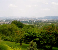
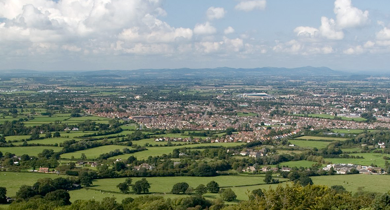
The Cotswold AONB was designated in 1966 and extended in 1990 and the unique setting of Cheltenham is derived from its location at the edge of the limestone escarpment, particularly to the south west, an area of high landscape value, dominated by the significant feature of Leckhampton Hill. In 2003 a report was commissioned entitled ’Land at Farm Lane / Church Road Leckhampton, Cheltenham – Landscape and Visual Appraisal’. The report concluded that the landscape value at Leckhampton was extremely important, as it complements and enhances the setting and natural beauty of the AONB (generally acknowledged to be one of England’s finest) and it should not be subject to large scale development. Areas nearby are considered precious enough to be included in greenbelt, with the crucial function of preventing urban sprawl and coalescence between Cheltenham and Gloucester. Furthermore, the land is important to wildlife for habitat and humans for recreation. In a knee-jerk reaction to central government, our councils are completely disregarding existing policies designed to protect green land and open space.
FLOODING RISK
This has justifiably been a source of anxiety since the appalling floods in 2007.
We lie at the foot of a steep limestone hill that is overlaid with impermeable clay. The hill is peppered with springs with two main water courses, Hatherley brook and Ham brook. After heavy rain the ground water running off the hill is able to soak away into the fields south of the A46. But during the extreme conditions of 2007 even this was not enough to protect the homes in Warden Hill. Climate scientists predict extreme weather patterns will become the norm due to climate change, so these natural soakaways will become even more important. Proposals by developers featuring ‘balancing ponds’ are an attempt to mitigate storm effects but we don’t think this will tackle the issue as successfully as nature does! A detailed and highly technical hydrological study carried out in 2010 states that the topography is more significant than the capacity of the brooks to cope with a flood event. We fear that adding ponds will not be sufficient to compensate for the surface water runoff created by development, especially in an extreme weather event.
A £650k flood protection scheme has been put in place, bizarrely all the new development proposed for Leckhampton is on the other side of this protection and in areas prone to flooding from surface water.
The JCS evidence base has provided valuable information on the increasing flood risk to the Leckhampton area and is in agreement with surface flooding experienced by residents in recent decades.
The Gloucester, Cheltenham & Tewkesbury Joint Core Strategy Level 2 Strategic Flood Risk Assessment, HALCROW Summer 2011, report extract covering the Leckhampton area:
‣Significant surface water runoff is generated from the area to the south
‣Areas of historic flooding identified outside the modelled flood risk areas
‣Two key risk areas identified along Hatherley Brook (upstream Church Road & rural land adjacent to eastern branch), a number of existing roads affected by flooding
Hatherley & Ham Brook in Leckhampton is identified as higher flood risk, a hydraulic model of Ham Brook is required, significant surface water runoff and an area of historic flooding, and highways are also affected. The Halcrow report again, ‘where historical records show incidents of flooding and surface water, then these areas should be treated as Flood Zone 3a; at risk and not suitable for development. Areas of existing open space acting as informal flood storage areas should be safeguarded from development’, the open fields at Leckhampton provide important protection of areas to the west of the Shurdington Rd from flood risk due to surface water. In general Halcrow state that, ‘areas of existing open space acting as informal flood storage areas should be safeguarded from development’.
This is the case in Leckhampton where open land is protecting Warden Hill where flooding has been a serious problem, a minimal flood protection scheme has been put in place on a small section of the Shurdington Road, it is worth noting that all proposed new development is on the other side of this barrier. The area of open countryside adjacent to the flooded area provides important protection to the wider area of Leckhampton Lanes & Warden Hill.
Halcrow again, 'in some areas high hazard surface water risk areas affect locations outside of Flood Zones 2 and 3. Such areas should be treated as Flood Zone 3a with regard to the Sequential Test process', the heavy clay soil at Leckhampton regularly floods due to water run-off from Leckhampton hill.
This whole area along Church Road (formally Collum street) has had problems with flooding, with tithing records dating back to medieval times due to the close proximity of Leckhampton Hill.
SOCIAL INFRASTRUCTURE
Very little provision is planned for additional school places, primary and secondary, with Leckhampton Primary, Bournside & Balcarras Secondary Schools are all full and places in high demand. Health care provision is currently under pressure; A&E at Cheltenham was downgraded in August, now sending serious cases to Gloucester Royal after 8pm. It remains to be seen how the reduced service will cope this winter…
EMPLOYMENT
Developers like to trumpet that hundreds of local jobs will be created for each scheme. They won’t – these are weasel words. The big volume house-builders tender the construction work across the country to get the best price. They import the winners, who will have their own network of sub-contractors (20-40 tradesmen), and use very few local people. Once the development is completed they move on. Additional homes may help support local retail, but very few ‘real’ jobs will be created. In fact we are losing jobs in Cheltenham - 7600 went between 1991 and 2009 and with the economy in its present state this pattern will continue.
New homes could destroy local jobs
A spokesman for Bovis Homes and Miller Homes was quoted in the Echo on September 19th as claiming that 650 homes they are applying to build in Leckhampton will create nearly 1000 jobs for the local economy. The developers made the same claim last February: that “1.5 jobs are created for every home built”. When challenged, they gave their source as a 2005 report: “The labour needs of extra housing output”. But what this report actually says is that 1.5 man-years of employment are created in the construction industry for every home built. So the proposed development would create nearly 1000 man-years of employment for the developers - not jobs for our local economy.
A recent Department for Transport report “Action for Roads” published in July warns that ill-planned development can damage competitiveness and destroy jobs. It predicts that traffic congestion will become so bad in some areas that people will no longer be able to commute to work. Places like London with good public transport should be OK, but places like Cheltenham that depend heavily on roads and commuting by car are vulnerable.
Traffic surveys and modelling recently conducted by Leckhampton with Warden Hill Parish Council show that if all the houses proposed by the draft JCS in Leckhampton and Brockworth were built, the morning A46 traffic queue into Cheltenham would stretch right to the A417. It could take an hour or more to commute into Cheltenham. Moreover, this does not include the extra traffic from the 850 homes now also proposed on the green belt south of Up Hatherley Way. With the A46 essentially blocked, traffic would divert via M5 junction 11, also making it harder to commute into Cheltenham from the west. Jobs would move elsewhere and new employment would be less likely to come to Cheltenham. Therefore, far from creating 1000 local jobs, development in Leckhampton and elsewhere on Cheltenham south-side could well destroy them.
Dr Adrian Mears CBE, Chairman LWWH Parish Council.
DEMOCRACY. There was enough time between the publication of those most recent ONS figures (upon which they should have applied their housing projection) and the vote in September for the JCS team to have revisited their projections and produced a more accurate figure which would have been lower. Why didn’t they do this?
Did you know that a council receives a bounty from central government, the new homes bonus of band D council tax for six years; for Cheltenham this is worth £1480 times six, a total of £8880 for every new house built, that would be £5.7 million for the 650 houses targeted for Leckhampton. How much is the 33,500 of the JCS worth to councils, a tempting prospect in these cash-strapped times, are our councils flogging off our precious land for short term gain?
For 20 years LEGLAG has fought to save the open fields in Leckhampton from being tarmaced, three Inspectors have agreed in major Planning Inquiries. We have a vision of what we would like for the future of this land: a Country Park managed as a bio-diversity and wildlife haven; a small City Farm where children can learn about food production; allotments; protected common land for the recreation of residents. What a legacy to pass on! But now we are in danger of losing this future to the profits of developers, their shareholders (who don’t live here!) and a cynical policy. Please have a look at the Neighbourhood Planning document, this is localism in action but will Cheltenham Borough Council try to understand and listen to the evidence ...
And as Oscar Wilde put it, ”A cynic…. knows the price of everything and the value of nothing.”
So GO to the public consultation between 15th October and 25th November and find out how it will affect YOU.
Locally, there will be a consultation event on Saturday 19th October 2.30 – 5.00pm at Leckhampton Village Hall and on Thursday 24th October 6.00-8.30pm at Shurdington Social Centre.
This will be the opportunity for you the public to scrutinise the details, to question inaccuracies and ambivalence, to demand clarity, to object to poor decisions and
TELL THE LIB DEM CABINET WHO CONTROL CHELTENHAM COUNCIL
Ann (525939) and Ian (250473)
JCS Public Consultation - Response
10 February 2014