
Ltd.
Joint Core Strategy
The NLP consultant report says there will be a ‘need’ for 28,500 houses in the JCS area based on an outdated DCLG housing model, for Cheltenham this equates to >20% growth not seen since 1830! Plus talk of even higher housing numbers for the wider JCS area, equivalent to a city the size of Gloucester foolishly justified by huge economic growth, would you believe projected growth levels significantly higher than the long forgotten boom decades. As you will already know LEGLAG do not agree with such a huge expansion with no sound evidence to back their claims. We believe in the ONS & SWEM growth projections and use of best practice from the Bristol Inspectorate, these predict a gradual return to pre-2008 levels of growth, 8% to 2030; however this will be difficult to achieve with the continued flatline in the national economy. Gloucester and Tewkesbury Councils sadly tend to agree with JCS numbers with very little debate; Cheltenham, heavily lobbied by residents, LEGLAG, STC & CPRE and others, continues to query the JCS housing numbers
-
‣JCS Response Report on Consultation carried out to Oct 2011.pdf
-
‣LEGLAG Report on Projected Future Housing, Richard Fordham Jan 2012 - Appendix A
-
‣ONS UK gross domestic product and net national income per head Oct 2012 4832Dd01.pdf
JCS Flood Risk Assessment (search for ‘Leckhampton’ in these reports)
Current CBC Local Plan & Previous inspectors reports rejecting large scale development in Leckhampton
Traffic Congestion - Look at the maps in this report
JCS Housing Numbers
-
‣GloucestershireHousingTrendAnalysisPopulationandHouseholdProjections(May2011).pdf
-
‣What the Census tells us on Housing and Households Cheltenham and Gloucestershire.pdf
-
‣What’s happening in Stroud on the Housing Numbers - Report from Don’t Strangle Stroud, Ian Stuart Feb 2013.pdf
Plato said that for something to be considered 'knowledge' it must satisfy three criteria: it must be justified, true and be believed. LEGLAG are totally justified in presenting new evidence to inform the JCS given the strength of public opinion voiced in the JCS consultation, we provide objective and referenced data not just opinion, being believed is the difficult part.
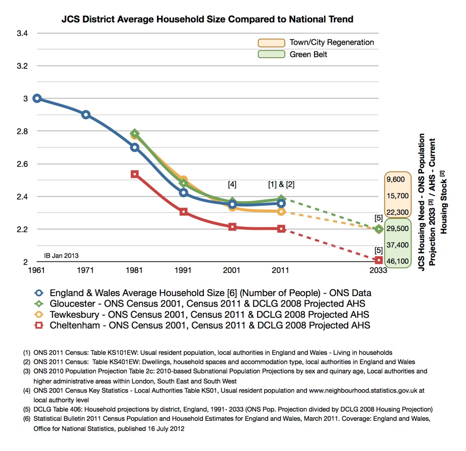
Currently under consideration is a JCS housing target of 28,500 (>20% growth) for the three districts, over a third of this housing is being derived from a large projected reduction in household size. However there is a conflict in the evidence presented, the JCS consultants are recommending the use of an old DCLG model. This outdated model predicts a 0.2 reduction in household size in Cheltenham over the plan period (please see dotted redline below), for the current housing stock of 50,000 this equates to 10,000 people which will need homes, increasing the housing target in Cheltenham by a further 5000.
However the Bristol Inspectorate (local plan hotline) who will be judging the soundness of our JCS & Local Plan through a process of Examination in Public have advised on best practice, basically the use of census data (2001 & 2011) as published by the Office of National Statistics (ONS) to access the household size at the district level. The new National Planning Policy Framework (NPPF) requires councils to use up-to-date & objective data, the best source of objective data, used by other councils, is the ONS census. This provides a very different picture on household size, at the national level is has been broadly flat for 20 years (blue line below), the JCS districts show flat or even increasing household size in Gloucester.
LEGLAG Evidence Base


The ONS have kindly provided all the data as recommended by the Inspectorate and checked the chart, the chart shows how sensitive the JCS housing target is to household size. A small drop of 0.2 using the old DCLG model immediately costs us the greenbelt at Swindon Village & open countryside in Leckhampton with early phasing of the JCS. The DCLG model makes poor projections on household size simply due to the use of 1971, 81, 91 & 2001 census data at it's heart which control the household formation probabilities. Accepting the >20% JCS housing growth on very weak evidence is likely to result in the loss of much valued farmland, green fields & habitat which can never be replaced.
The documents in this section provide the core evidence on housing targets for the JCS area Tewkesbury, Gloucester & Cheltenham. The population projections for the three districts are taken from the Office of National Statistics (ONS) tables and referenced. These are broadly accepted, however they do contain a healthy level of pre-2008 economic growth, 8% to 2020, and are simply a linear projection of population growth from 2001 to 2011 using the two census points.
The household size remains an issue where we cannot get agreement with the JCS Officers. In the JCS public consultation hundreds of people, the majority of Parish Councils & many organisations wrote to the JCS to question the household size assumptions and how these assumptions have inflated the JCS housing targets. After much research, we have found the JCS team are using an out-of-date England model operated by the Department of Communities & Local Government (DCLG), household size is an estimated output however it uses census data going back to 1971 and it's output lags the actual household size published by the ONS; this amounts to a large error which greatly inflates the accessed JCS housing need. The Bristol Inspectorate where contacted, the Inspectorate Local Plan team is advising Local Authorities to use ONS district data, this is 'best practice'. In detail, to use a linear projection of census 2001 & 2011; that would be 2.36 for both 2001 & 2011 in the JCS area, please see the chart and note the housing scale on RHS. The chart below shows how the incorrect use of the DCLG model pushes the JCS housing need onto the Greenbelt and open countryside.
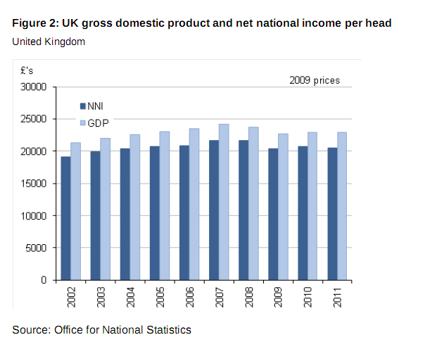
It is useful to correlate the trend with GDP & Net National Income per head (adjusted for inflation), please see the links on the chart, ref. ONS Measuring National Well-being, The Economy - 23 October 2012. Note, Figure 10 & notes (p33) in the ONS Statistical Bulletin, 'this information is critical for local authorities for assessing and planning for housing needs'. The JCS consultants are saying the flat-lining of the household size is a temporary blip brought about by the downturn in the economy since 2008, the data does not support this conclusion.
Not using actual & latest data to access district household sizes is non compliant with the NPPF, where it stresses the use of up-to-date evidence & data in the preparation of local plans, in actual fact the phrase up-to-date is used sixteen times in the document. Reference, NPPF Para 218, 'Local planning authorities may also continue to draw on evidence that informed the preparation of regional strategies to support Local Plan policies, supplemented as needed by up-to-date, robust local evidence'.
The use of the old DCLG model has even been questioned in the House of Commons, and our own MP Martin Horwood is busy trying to get to the truth on best practice, what objective and robust evidence should be used to guide the JCS.
Use of DCLG model to access district household size
Neil Carmichael MP raised the question on the use of out dated DCLG projections in the preparation of Local Plans.
House of Commons question on Housing:
Neil Carmichael: To ask the Secretary of State for Communities and Local Government what comparative assessment he has made of the compatibility of Office for National Statistics census data and his Department projections for local authorities for household size in terms of their respective weighting when informing local decision-making for housing core strategies - 10 Sep 2012.
Nick Boles: The National Planning Policy Framework requires local planning authorities to identify the scale and mix of housing that the local population is likely to need which meets household and population projections. This evidence informs the Local Plan which is examined by the Planning Inspectorate. The Department for Communities and Local Government does not undertake central assessment of the data used by local planning authorities to inform local decisions on identifying housing need.
The DCLG2008 household projection, table 406 has the following warning notes:
-
‣Are not an assessment of housing need or do not take account of future policies. They are an indication of the likely increase in households given the continuation of recent demographic trends
-
‣Sub regional household projections are less robust than those at the regional level, particularly for those areas with relatively small numbers of households
-
‣The sub regional household projections are not 'National Statistics'
Cllr Ian Bickerton
250473
Evidence from inspectors refusing development in Leckhampton
Four inspectors have rejected large scale developments on Leckhampton white land, to quote Inspector David Asher, “development of the objection site would materially harm the rural character and appearance of the area, and the important contribution that this makes to the landscape within the site and when seen from the AONB, the rural character up to the edge of the town which would be lost if development were to take place” - CBC Local Plan Second Review to 2011 Inspector’s Report.
1993 Inspector Brian Dodds,
6.92 The land at Leckhampton should be protected for its special historical, landscape and amenity value. It represents the last example of the gradual transition between the urban area and the countryside which characterised the Regency town. It should be considered anew for green belt or AONB status, for ‘landscape conservation area’ status, and as part of a Leckhampton Conservation Area (35A, 129W).
6.95 The land at Leckhampton continues to be farmed with no indication of decline. The structure plan says that development which leads to additional traffic on Bath Road will be resisted, as improvements would be damaging to the environment. The present sewerage system cannot accommodate even limited development on the Leckhampton land, and the Hatherley Brook is loaded to capacity.
6.97 The land at Leckhampton was originally omitted from the green belt with the proviso that the green belt notation might be extended if it appeared at a later date that it should remain open in the long term. The CELP [Cheltenham Environs Local Plan] Inspector concluded that the principles which guided the planners in 1968 applied equally in 1984, and that the land should not be green belt, but should remain open. I have had the benefit of new evidence concerning the character, appearance and historic interest of the land. I have walked over it and examined it from Leckhampton Hill, and reached my own conclusions on its merits. I have also examined Swindon Farm, which the CELP inspector was not asked to do. The GSPFA [ Gloucestershire Structure Plan First Alteration]with its strategy of restraint, in great contrast to the high level of development which occurred in the 1980s, was approved only recently (in 1992). In my opinion these are material changes, which have occurred since 1984, in the circumstances surrounding the question of longer term development in Cheltenham.
5.100 I believe that it would be very sad indeed if development were to proceed at Leckhampton, with its variety and interest
6.103 The land at Leckhampton appears from the latest available classification (MAFF 1) to be a mixture of Grade 2, 3a and 3b. Although not of the highest quality, the land is in my opinion sufficiently valuable for this factor to be given some weight if it ever becomes necessary to consider whether the land ought to be released.
6.104 The Structure Plan supports the council’s contention that Bath Road does not have the traffic capacity to support further development. There is insufficient evidence for me to draw conclusions about the drainage question: there is, at the least, serious uncertainty. Whether these constraints might be overcome in the longer term is not a matter which I need to address. However, they seem to me to be of such importance, and to have implications for such a wide area, that it is reasonable to conclude that the land at Leckhampton would need to be the subject of comprehensive development proposals if it were ever to be developed, as the council suggest. In the meantime, it should in my view continue to be protected from development.
Inspector Mary Travers who conducted an Enquiry on Leckhampton development and reported, 2003
2.25.11 The site consists of four fields subdivided by substantial hedgerows that are interspersed with hedgerow trees. It has a gently rolling, topography and an attractive pastoral character that in my view links strongly into the landscape of the AONB immediately to the south of. Leckhampton Lane. Generally the contours fall from south to north and from east to west and there is a distinct ridge running roughly northwest-southeast through the site- -so that the south-eastern corner is the most elevated part. A public footpath that traverses the northern part of the site forms a link in a network of rural paths to the east and west of the site.
2.25.12 As can be observed from public vantage points, the site is highly visible from within the AONB, for example from the lower slopes of Leckhampton Hill and from higher up at the Devil’s Chimney. It is also visible partly from the west and in long distance views from the north. There is a substantial hedgerow on the western boundary with the Green Belt but this area drops away towards the Vale of Gloucester As a result, development on the more elevated south-eastern part of the site would be very conspicuous from the western approach along Leckhampton Lane where it would be seen within the context of the AONB. And looking southwards from the public footpath across the site it is apparent that development would. entail a significant intrusion into views of the open countryside and the AONB from the existing edge of the built-up area. It would also sever the link between the rural footpaths to the east and west of the site and replace it with one of an entirely different character. For these reasons and taking into account the scale of the proposed development, I consider that its visual impact on the surrounding countryside would be very significant and that it could not be easily mitigated.
13. In addition, the site forms part of a swathe of open land that sweeps down from the Cotswolds to pass between Cheltenham and Gloucester and it provides a link between the AONB and the Vale of Gloucester. Development of the site would form an incongruous promontory in this open area, eroding the link and cutting off the rural land to the east of Farm Lane from the tract of countryside to the west. I do not consider that there are any differences in character or appearance between the Cheltenham Borough safeguarded land and the SH1 site that are so significant as to render this incursion less harmful.
Extract from Report of Inspector David Asher into the Cheltenham Local Plan, 2005
10.147 I conclude on this issue, therefore, that the development of the objection site would materially harm the rural character and appearance of the area, and the important contribution that this makes to the landscape within the site and when seen from the AONB.
The recent JCS Entec Greenbelt Review (p528) recommended consideration of land to the south Leckhampton be incorporated into the Green Belt
Gloucester, Cheltenham & Tewkesbury Joint Core Strategy Level 2 Strategic Flood Risk Assessment, HALCROW Summer 2011.
-
‣Significant surface water runoff is generated from the area to the south
-
‣Areas of historic flooding identified outside the modelled flood risk areas
-
‣Two key risk areas identified along Hatherley Brook (upstream Church Road & rural land adjacent to eastern branch), a number of existing roads affected by flooding
-
‣Areas of existing open space acting as informal flood storage areas should be safeguarded from development
This is the case in Leckhampton where open land is protecting Warden Hill where flooding has been a major problem in the past, some recent flood protection work has been completed but the area of open countryside adjacent to the flooded area affords important protection. Jo can give more background to the flooding in Warden Hill and the limited flood barrier now in place.
Halcrow again, 'in some areas high hazard surface water risk areas affect locations outside of Flood Zones 2 and 3. Such areas should be treated as Flood Zone 3a with regard to the Sequential Test process', heavy clay soil at Leckhampton regularly floods due to water run-off from Leckhampton hill.
NPPF Neighbourhood Planning & Local Green Space Application
-
‣Biodiversity 2020 Meeting Schedule: The Challenge for Local Authorities and Public Bodies.pdf
-
‣DEFRA Biodiversity 2020 A strategy for England's wildlife and ecosystem services.pdf
-
‣Local food within Gloucestershire by Jonathan Somper, University of Gloucestershire (Sep 2006).pdf
-
‣The Ecological value of the Leckhampton White Land, Prof. Adrian Phillips - Appendix F
http://www.bbc.co.uk/news/uk-21602650
Farming leaders are urging supermarkets to stop scouring the world for the cheapest food. At the National Farmers' Union (NFU) conference president Peter Kendall said supermarkets should source traceable products from British farmers. Environment Secretary Owen Paterson said farmers should not be tarnished by criminals' fraudulent activities over the horsemeat scandal. Earlier, the head of Tesco pledged to bring meat production "closer to home." Philip Clarke, who later addressed the conference in Birmingham, told the BBC he would work more closely with British farmers in response to the horsemeat scandal. He told the conference: "Where it is reasonable to do so, we will source from British producers. As a first step I announce that from July all of our fresh chicken must come from UK farmers. No exceptions”.
Loss of residential amenity
Loss of visual amenity
The site is a Greenfield site and therefore development contravenes planning policy
The conclusion reached at the public inquiry following the previous application to develop the site still applies
Loss of valued and extensively used informal open space
Impact on biodiversity
Loss of historic environment
Negative effects on health
The piecemeal encroachment of development
Degradation of the rural character of Leckhampton
ARCHIVE
Firstly a big thank you for the tremendous support given to the LLR GOSW petition. We received over 95% signed letters and our petition was duly submitted to Mrs Louise Harrison (Senior Planning Manager, Gloucestershire and Wiltshire - GOSW) on the 14th Nov. 2005. It did make a difference, the GOSW are now monitoring policy SD2 carefully to enforce three important conditions which they have stipulated must take place before any planning application can be considered:
-
‣Joint planning with Cheltenham Borough Council on the extension to the PUA - we had a meeting with CBC in Dec. 2005 (Tracey Birkinshaw - CBC Strategic Land Use Manager), CBC have no plans to develop Leckhampton and have always been opposed to policy SD2.
-
‣Greenbelt Review and Phasing, to quote GOSW, 'phasing of strategic sites allows for their review should the Green Belt Review conclude that these were inappropriate' - Leckhampton scored highly in this review as reported in the local press (sorry for the LLR misquotes, the Echo have apologised) - please see Ref. 5
-
‣Finally on the sustainability, lack of services and congestion etc. to quote GOSW again, 'No permission will be granted prior to the site's strategic justification'
Working together has strengthened our capacity to influence the GOSW, SWRA and now Cheltenham Borough Council.
We are working on all three of these conditions in discussion with the GOSW (please see follow up letter to Mrs Helen Thomas - Planning Manager Gloucestershire) and our correspondence with the SWRA - Mr Peter Brown, Director of Policy and Planning.
Currently the LLR are preparing a submission and/or meeting with Highways to discuss policy SD2 and their statements made in the TBC Agenda & Objections [Ref. 4] d. 18 October 2005. Please email us, or call if you have other ideas on other future action we might take.
-
1.Tewkesbury Borough Council Local Plan To 2011 Report Of Public Local Inquiry Into Objections PINSM/G1630/429/5 December 2003 - Mary Travers Ba(Hons) DipTP MRTPI - The Planning Inspectorate. Tewkesbury Borough Council Local Plan To 2011 Report Of Public Local Inquiry Into Objections PINSM-G1630-429-5 December 2003 Mary Travers.pdf
-
2.Cheltenham Borough Local Plan Second Review 1991-2011 Inspector's Report, pp 187, DP527 8 March 2005 David Asher BA DipTP MRTPI. Cheltenham Borough Local Plan Second Review 1991-2011 Inspectors Report pp 187 DP527 8 March 2005 David Asher.pdf
-
3.Government Office South West statements & objections on the TBC Local Plan, containing the conditions stipulated for policy SD2, via email L. Harrison (Senior Planning Manager, Gloucestershire and Wiltshire).- view (pdf file)
-
4.Tewkesbury Borough Council Agenda & Objections, dated 10 October 2005, meeting by full Council in Council Chambers on 18 October 2005 to vote on the TBC Local Plan to 2011, pp 93.
-
5.Draft Regional Spatial Strategy: Submitted Version (April 2006) - Open the full document and search for 'Cheltenham Spatial Strategy', - page 60 for the map, and p62 (starting at para. 4.2.40) for the detail on Cheltenham. Public consultation is now underway - June 2006 to August 2006, see above.
http://www.southwest-ra.gov.uk/swra/ourwork/RSS/RSS_final_draft_version_doc.shtml
-
6.Gloucestershire County Council Consultation Results - Shaping the Future of Cheltenham and Gloucester to 2026
Work undertaken on behalf of the South West Regional Assembly:
http://www.gloucestershire.gov.uk/environment/vision2026/Forum%20Report.pdf
7. Here's the Buchanan Greenbelt (Feb. 2006) report link for reference:
http://www.southwest-ra.gov.uk/swra/ourwork/RSS/RSS_greenbelt.shtml
The Cheltenham and Gloucester JSA aimed to differentiate the importance
of protecting different areas of countryside by assigning different weights or
scores to the areas. The officers undertook site visits to key areas within the
Green Belt and these were then scored against the five purposes. A "0"
implied little or no importance, a "1" implied some importance, and "2" implied high importance. These results are provided in Appendix 4.
All potential boundary review sites are assessed given available
information on Green Belt purpose in a table, firstly identifying the amount
of purposes fulfilled by each, and, secondly, by weighting the main
purposes of Green Belt ahead of other purposes (which is based on the
reasons why Green Belt was originally established). Results of these
analyses are provided in Appendix 10. & the Maps in Appendix 11:
Cheltenham Borough Local Plan Inquiry (1993) - Inspector's Report, relevant pages to Leckhampton (thanks to Ken Pollock, not available on the CBC website) - it has excellent support material and is very useful background reading.